Latest update
A number of plans for project sites have been submitted to the planning and land authority for approval. For more information, and to provide comment on these Development Applications visit: ACT Healthy Waterways Sites and Progress.
Key facts
- The highest levels of pollution entering the lake come from the Kambah and Wanniassa stormwater drains.
- This network of older stormwater pipes and concrete-lined channels were designed to move run-off into Lake Tuggeranong as quickly as possible, along with pollutants like leaves, chemicals, animal faeces and grass clippings.
- Tuggeranong Creek feeds into Lake Tuggeranong which, in turn, flows into the Murrumbidgee River.
- Large volumes of untreated water frequently overwhelm the capacity of the lake to process pollutants, creating conditions that lead to blue-green algal blooms.
Expected benefits
- The priority projects will remove 689,100 kg/year of suspended solids, 954 kg/year of phosphorus and 4533 kg/year of nitrogen from stormwater inflows to the lake.
- Other benefits include enhanced open space, an increase in the diversity of the area’s natural habitat and the potential for irrigation of local sporting fields.

Priority Project 1 - RAIN GARDEN AND POTENTIAL STORMWATER USE
Chirnside Circuit, Kambah
A new rain garden in open space south of the Kambah West District Playing Fields near Drakeford Drive will improve the overall ecology and amenity of the site. The existing cycleway will not be affected but some trees may need to be removed to allow for construction. (TG003)
Click here for full size version of plans. (TG003)

Share your views on Lake Tuggeranong Priority Project 1.
Priority Project 2 - RAIN GARDENS AND POTENTIAL STORMWATER USE
Athllon Drive between Langdon Avenue and Fincham Crescent, Wanniassa
A series of rain gardens will be established adjacent to St Anthony’s Primary School near Athllon Drive. Some of the captured and treated stormwater may be used to irrigate Wanniassa Playing Fields (TG008).
Click here for full size version of plans. (TG008)

Share your views on Lake Tuggeranong Priority Project 2.
Priority Project 3 - RAIN GARDEN
Upper Stranger Pond, Isabella Plains
A rain garden upstream from Upper Stranger Pond will help remove sediment and nutrients from stormwater. Depending on conditions, water from the pond could be used to irrigate Isabella Plains Neighbourhood Oval and nearby playing fields. The area will also be landscaped to incorporate vegetation and planting beneath existing trees. (TG010)
Click here for full size version of plans. (TG010)

Share your views on Lake Tuggeranong Priority Project 3.
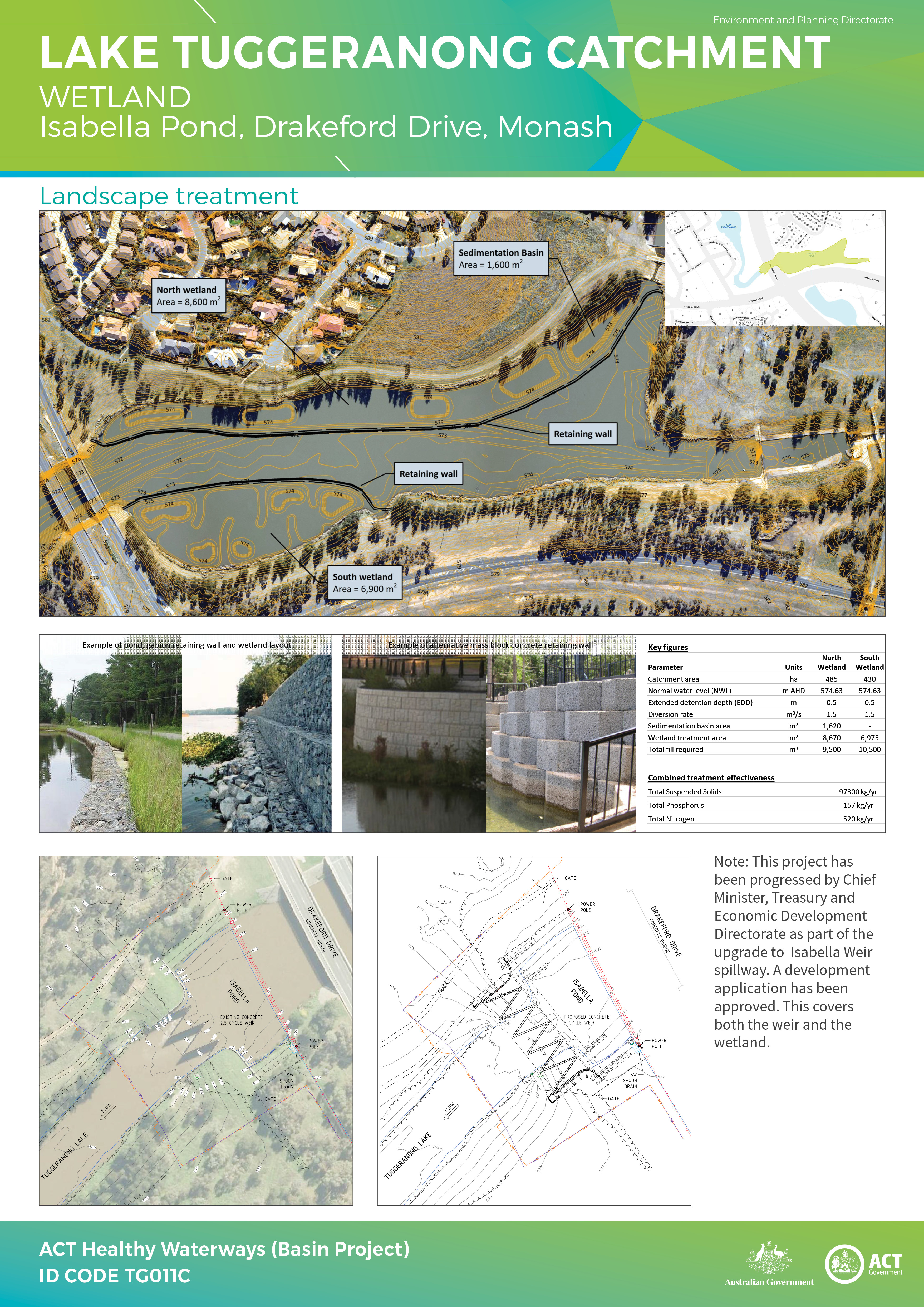
Priority Project 4 - Wetland
Isabella Pond, Drakeford Drive, Monash
A wetland will be constructed on the edge of Isabella Pond in conjunction with the proposed upgrade of the Isabella Weir spillway for flood mitigation purposes. These improvements will help remove nutrients from the stormwater that enters Lake Tuggeranong via the pond. (TG011C)
Note: This project is funded directly by the ACT Government and has been progressed as part of the broader Isabella Weir spill-way upgrade works (for flood mitigation) being undertaken by Chief Minister's Treasury and Economic Development Directorate. A development application has been approved. This covers both the weir and the wetland.
Priority Project 5 - Swale
Corlette Crescent, Monash to Isabella Pond
Part of the concrete channel between Corlette Street, Monash and Isabella Pond will be converted to a swale. Vegetation in the swale will help treat stormwater before it enters the pond and increase the diversity of the areas natural habitat. The swale will occupy a wider area compared to the current concrete channel. (TG012)
Click here for full size version of plans. (TG012)

Share your views on Lake Tuggeranong Priority Project 5.
Priority Project 6 - RAIN GARDEN AND POTENTIAL STORMWATER USE
Open space north of Isabella Drive near Kirkcaldie Circuit, Chisholm
The new rain garden may be combined with an irrigation system so captured and treated stormwater can be used to irrigate Chisholm District playing fields. While some existing trees will need to be removed, the project includes extensive landscaping and new planting (TG023).
Click here for full size version of plans. (TG023)

Share your views on Lake Tuggeranong Priority Project 6.
Priority Project 7 - RAIN GARDENS
Fadden Pines Reserve, Fadden
Two rain gardens will improve the open space between Isabella Drive and Coyne Street. The area will also be landscaped to incorporate vegetation and filtering media to remove nutrients and sediment. The design minimises the removal of existing trees and leaves a large landscaped area as a recreational space for the local community (TG029).
Click here for full size version of plans. (TG029)

Share your views on Lake Tuggeranong Priority Project 7.
Priority Project 8 - POND AND POTENTIAL STORMWATER USE
Between Kett Street and Drakeford Drive, Kambah
A new pond in open space near the Burns Club will capture stormwater that could be used to irrigate the adjacent Kambah East District Playing Fields. The site will be landscaped to enhance the existing open space. (TG030)
Click here for full size version of plans. (TG030)

Share your views on Lake Tuggeranong Priority Project 8.
Priority Project 9 - IN LAKE RESEARCH
Lake Tuggeranong
Lake Tuggeranong will be part of a three-year catchment research project to improve understanding of how changes in sediment movement and oxygen profiles affect algal blooms, for example:
- managing change in the movement of sediment, potentially using sediment curtains
- managing dissolved oxygen profiles, potentially using a bubblers.
Note: Work is progressing on identifying the scope of the research project.
RESERVE PROJECTS
Reserve projects have been identified for each catchment to allow for contingencies that may emerge during detailed design or construction.
These projects may go ahead if any of the priority projects are no longer considered viable, unexpected savings are made in completing the priority projects, or additional funding becomes available. Designs have been prepared for the 10 highest ranked reserves across the six priority catchments. In the Tuggeranong catchment designs have been prepared for:
RAIN GARDEN AND POTENTIAL STORMWATER USE
Bugden Avenue, opposite Kellett Street, Gowrie
- Treated water will flow to two storage tanks buried underneath a rain garden.
- This will maximise the filter area of the treatment system and reduce the visual impact of the tanks.
- Tank overflows could be diverted to an adjacent stormwater pipe.
- A pump and rising main would be used to irrigate the playing fields. (TG017)
Click here for full size version of plans. (TG017)

Reserve Project - Bugen Ave, opposite Kellett Street, Gowrie
RAIN GARDEN AND POTENTIAL STORMWATER USE
Opposite Viking Park, McBryde Cresent, Erindale
- A rain garden will help remove sediment and nutrients from the urban catchment.
- The rain garden has been positioned to maximise trees retention. The rain garden will improve ecosystem value through increased diversity in habitat. (TG014)
Click here for full size version of plans. (TG014)

Reserve Project - Opposite Viking Park, McBryde Street, Erindale
RAIN GARDEN
North of De Little Circuit, Greenway
The rain garden has been positioned to make use of the open space adjacent to Lake Tuggeranong. The rain garden will improve ecosystem value through increased diversity in habitat. The pedestrian and cycle access will be maintained. (TG007B)
Click here for full size version of plans. (TG007B)

Reserve Project - North of De Little Circuit, Greenway
RAIN GARDEN
North of Holy Family Primary School, Weathers Street, Gowrie
The rain garden would be tiered with two elevations to make use of the slope on site to minimise excavation. The associated landscaping will improve the ecosystem and biological diversity and restore a degraded section of remnant woodland. Paths and seating will also improve the amenity of the site. The path that currently runs north–south through the site would be replaced by a boardwalk (TG018).
Click here for full size version of plans. (TG018)

Reserve Project - North of Holy Family Primary School, Weathers St, Gowrie
Designs for these projects will only be prepared if needed.
- RAIN GARDEN AND POTENTIAL STORMWATER USE - Behind Taylor Primary School, Marconi Crescent, Kambah (TG004)
- RAIN GARDEN AND POTENTIAL STORMWATER USE - Between Bellingham Crescent and Severne Circuit, Wanniassa (TG005)
- RAIN GARDEN - Between Longmore Crescent and Sainsbury Street, Wanniassa (TG009)
- RAIN GARDEN - Near O’Halloran Circuit and Athllon Drive, Kambah (TG013)
- RAIN GARDEN - Between McBryde Street and Erindale Drive, Erindale (TG015)
- RAIN GARDEN - Between Upton Street and Ashley Drive, Monash (TG016)
- RAIN GARDEN - Opposite Humffray Street, Wanniassa (TG031)
Contact Us
Have questions or want to learn more about a project, contact us below:
| Name | ACT Healthy Waterways (Basin Project) |
|---|---|
| Phone | 132281 |
| epd.basinproject@act.gov.au | |
| Website | www.act.gov.au/basinproject |


