
The Framework identifies areas where housing density could increase along the corridor, subject to further investigation. In line with the approach to locate more housing close to shops and rapid transport, new development will generally be focused in existing residential areas within:
- 800 metres of rapid transport stops
- 1,000 metres of Woden town centre
- 800 metres of group centres (Curtin and Mawson)
- 400 metres of local centres
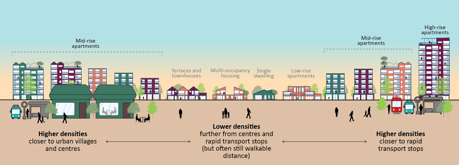
This approach, known as gentle densification, aims to gradually increase housing density in a way that is small-scale, human-centred, and respectful of existing neighbourhood character and walkability. The image below outlines the mix of housing types proposed across the corridor to support population growth and community needs in the areas where it is most appropriate.
Mid-rise housing will be concentrated around activity centres and near light rail stops, rapid bus stops, and local and group centres. Building heights will transition down towards established low-rise suburban areas, supporting the government’s commitment to gentle densification.
High-rise housing will be limited to Woden town centre. Higher-density development is also suitable for the north Curtin residential area, where there is strong access to transport, services, community facilities, and amenities.
Lower-density housing will remain in areas further from centres and rapid transport stops, although many of these locations will still be within walking distance of key destinations.
New housing opportunities in the corridor will be delivered gradually over coming decades, responding to the needs of a growing community.
Appropriate housing scales within the corridor
The Framework is a non-statutory document, meaning that while it does not determine outcomes, it will provide direction for future changes to the planning controls along the corridor.
Any proposed changes that put the Framework into action will be rolled out gradually, and each stage will include consultation and opportunities for community feedback before decisions are made.
The Services Trades (CZ3) Technical Paper is an evidence-based report that examines the role, performance and future of CZ3 (Services) zoned land across the ACT.
CZ3 land supports businesses that provide services, trade supplies, storage, logistics and low impact industrial activities, such as vehicle repairs, workshops and small-scale manufacturing. These areas provide important employment opportunities and often offer more affordable commercial space than town centres.
The paper reviews how CZ3 areas are performing, identifies opportunities and challenges and provides strategic recommendations to help inform future planning decisions. It includes a detailed assessment of the phillip service trades area, responding to the Minister for Planning's request for further work on the future of the precinct and outlining six planning options for consideration.
The technical paper does not change planning policy or zoning. Instead, it provides the evidence and analysis to support future planning work and decision-making.
In 2024, the ACT Government commissioned the Community, Sport and Recreation Facilities Needs Assessment and Social Infrastructure Audit, which looked at facility needs across most ACT districts. This was an ACT wide study.
Using the information from this audit, a Southern Gateway Community Needs Assessment was prepared to better understand current and future community infrastructure needs across the corridor. Social infrastructure includes the places and services that help people live healthy, connected lives, such as schools, health services, parks, libraries, community centres, meeting places and sporting facilities.
The Southern Gateway Community Needs Assessment is being released alongside the Framework to support informed community feedback. The assessment provides an evidence base to support long-term planning and investment. It will help inform conversations with the community and guide future decisions about the type, location and timing of social infrastructure needs to support growth along the corridor.
The Southern Gateway Community Needs Assessment helps ensure that planning for the Southern Gateway is not just about housing and transport but also about providing the facilities, services and spaces needed to support a growing and changing community.
The Southern Gateway Community Needs Assessment identified several key trends and opportunities:
- Growing demand: Population growth and increasing density are creating opportunities to expand and enhance community, sport and recreation facilities, particularly in Woden, to support a larger and more active population.
- An ageing population: There are opportunities to strengthen aged care, health services and integrated models of care that support people to age well within their communities.
- Expanding community spaces: Demand for spaces that support young people, older residents, arts, culture and flexible community activities presents opportunities to diversify and modernise the community infrastructure network.
- Sport and recreation growth: Increasing participation in sport and recreation creates opportunities to invest in indoor sports facilities, outdoor courts and youth-oriented recreation spaces, like skate and BMX infrastructure.
- Education and childcare development: Population growth provides opportunities to expand schools and early childhood services, improve accessibility and support greater provision by not-for-profit providers.
- Enhancing open spaces: Existing open space assets provide opportunities to improve accessibility, functionality and supporting amenities, such as dog parks and community gardens, to support higher-density within neighbourhoods.
- Responding to changing community needs: Increasing cultural diversity and evolving household structures create opportunities to deliver more inclusive, accessible and adaptable services, facilities and programs that meet a wider range of community needs.
A Community Needs Assessment is a way of understanding what facilities, services and spaces a community has now, and what it will need in the future. It looks at population growth, existing infrastructure (like community centres, sports facilities and open space) and whether there are any gaps or areas where demand is increasing.
It combines data, planning analysis and community input to build a clear picture of local needs. This helps guide decisions about where new facilities are needed, how existing ones can be improved, and how to plan for a growing and changing community so people can continue to live well.
For the Southern Gateway Corridor, the needs assessment:
- Identifies existing community and social infrastructure across the corridor
- Uses population forecasts, benchmarking and best practice research to understand future needs
- Considers opportunities to improve access to community infrastructure and coordinate future delivery
- Helps inform long term planning and investment decisions
- Provides an evidence base to support community engagement and future planning.
Once engagement closes a listening report will be prepared and released to the community. The feedback received will be used to inform the final Framework.
Once the final Framework is released, it will guide how the area grows and changes over time.
This won’t be the last chance for community input. There will be more opportunities to have your say as planning progresses in the corridor. If planning proposals or changes to planning controls are developed to implement the Framework, they will be consulted on separately through the ACT Planning website in accordance with legislative requirements.
Future changes to planning controls and policy
The Framework is a strategic planning document that sets out a long-term vision for the corridor to 2050 and beyond. While it does not change planning rules, it will help guide future planning and development decisions.
To support this vision, changes to planning controls will be needed through updates to the Territory Plan and, in some areas, the National Capital Plan. The ACT Government and the National Capital Authority will work together on these changes and continue to consult with the community as specific proposals are developed.
Updates to the Territory Plan (the ACT's planning “rulebook”) are made through Major Plan Amendments. These amendments can enable significant changes, such as new housing, shops, offices, community facilities and changes to building heights.
Key things to know about Major Plan Amendments:
- Changes will be introduced in stages over time rather than all at once.
- Each stage will focus on different parts of the corridor, starting with priority areas identified for change.
- Every Major Plan Amendment includes opportunities for community consultation and feedback before decisions are made.
Future Major Plan Amendments and planning proposals will be consulted on separately through the ACT Planning website in accordance with legislative requirements. They are not part of this YourSay consultation.
In simple terms, Major Plan Amendments are the process used to update planning rules to support future development.
You can learn more about the Territory Plan and Major Plan Amendments by visiting the ACT Planning website.
While the Framework does not determine future development outcomes, it will help guide future Major Plan Amendments and also inform the review of District Strategies, which occurs every five years.
The Draft Southern Gateway Planning and Design Framework is a plan for 2050 and beyond.
The draft Framework is a non-statutory document, meaning that while it does not determine outcomes, it will provide direction for future changes to the planning controls along the corridor.
To put this Framework into action, changes through the planning system will be needed to update the Territory Plan, and in some instances, the National Capital Plan. The ACT Government and National Capital Authority will work together on these changes.
Updates to the Territory Plan are made through Major Plan Amendments. Amendments will happen in stages, focusing on different parts of the corridor over time.
- Each stage will look at specific precincts, starting with areas identified as priorities for change.
In simple terms, major plan amendments are how planning rules are updated when bigger changes are needed and the community plays an important role in shaping them.
These changes won’t happen all at once. They will be rolled out gradually, and each stage will include consultation and opportunities for community feedback before decisions are made.
It is anticipated that improvements to infrastructure and services to support new housing will be aligned with growth over the duration of the Framework.
No, the draft Framework does not support housing on the Mint Ovals. The Framework proposes investigating expanding the ovals to support the growing sport and recreational needs of the community.
No, the draft Framework does not support housing on the Mawson Playing Fields. The Framework proposes investigating expanding the playing fields onto the former driving range to support the growing sport and recreational needs of the community.
It is proposed that the edges of Athllon Drive support mid-rise housing adjacent to the Playing Fields.
The draft Framework supports mid-rise housing along the corridor close to high frequency bus and light rail stops with the exception of the Woden Town Centre where ‘high-rise’ is already permitted. The Curtin Residential Area would support ‘higher density’ housing but not ‘high rise’.
Low-rise ‘Missing Middle’ housing will form part of the broader corridor. However, consistent with the ACT Planning Strategy, and transport oriented development principles, the draft Framework proposes greater density of development in well-located areas including:
- frequent bus network corridors (800 metres/ average 10 minute walk)
- light rail stops (800 metres /average 10 minute walk)
- city centre and town centres (1000 metres/average 15 minute walk).
- group centres (800 metres /average 10 minute walk).
No, the draft Framework proposes that Rapid bus connections continue to run from Tuggeranong, Weston Creek, Molonglo and the Inner South through to the City interchange.
The draft Framework does propose improvements to bus stops and interchange points in the future network as well as park and ride opportunities and active transport connections.
The ACT Government is proposing to protect the Phillip service trades area from residential development in the Framework, consistent with the current Territory Plan. However, the Government is interested in hearing from the southside community and businesses on whether changes to this approach should be considered in the future.
A Service Trades (CZ3) Technical Paper has been prepared and is attached to the draft Framework to inform this discussion. It provides an overview of existing uses, constraints and opportunities in the service trades area and is intended to support conversations about how precincts such as Phillip Trades can evolve while retaining its core service role.
Yes, the ACT Government will support the supply of affordable, community and public housing in the Southern Gateway corridor.
Any sites in the Southern Gateway corridor that are released by the Government and are suitable for residential development will be considered for inclusion of affordable, community and public housing.
The Government will also seek to examine further opportunities to encourage affordable, community and public housing on leased land through inclusionary zoning reform and incentives. This may include temporary reductions on lease variation charges (LVC) for social and affordable rental housing and may require or encourage developers to include affordable housing as part of precinct-scale residential developments.
These initiatives will help to increase affordable housing supply, access, and choice to meet the housing needs of the community in the Southside.
Yes, Adelaide Avenue was originally conceived in the Griffin Plan as a formal, tree-lined and active boulevard with dense development along the public transport corridor, serviced by light rail.
“The urban form of Griffin’s city was concentrated on the perimeter of the National Triangle along the Main Avenues and around the business centres at the junctions of the avenues. Building intensity gradually decreased away from the Main Avenues, buildings merging with landscape as the city reached the inner hills.” (Griffin Legacy, 2004).
Yes, States and territories have committed to undertaking expedited zoning, planning and land release to deliver the joint commitment in ‘well‑located’ areas.
National Cabinet has agreed to the National Planning Reform Blueprint including:
Measure 5 - Planning Ministers will streamline approval pathways and prioritise planning control amendments to support diverse housing across a range of areas, including promoting medium- and high-density housing in well-located areas close to existing public transport infrastructure connections, amenities and employment.